
22 Best Hikes in Madeira: From Easy Levadas to Hard Peaks (Personally Tested)
If you’re looking for the best hikes in Madeira, you’ve probably already seen pictures of its chiselled mountains peeking through the clouds or those sunset shots over the cliffs. Madeira’s hiking trails are really in a league of their own, especially because the variety is incredible for such a small island.
There are mountain trails that climb above 1,800 metres with ridge walks and dramatic views. Elsewhere, levada walks follow the island’s irrigation channels through laurel forest. And finally, there are coastal paths with views of the Atlantic, fishing villages and big cliffs.

In my Madeira hiking guide, I’m sharing the best hikes in Madeira that I’ve personally completed over 6+ months on the island.
The ‘best’ hike for you will, of course, depend on your fitness level, how much time you have and whether you’re visiting Madeira without a car. I’ve included quick, practical notes for each trail and who it suits best, plus photos and tips on how to include a stop at some of the best cafés in Madeira post-hike!
Disclosure: This post may include affiliate links. If you decide to click through and make a qualifying purchase, I will receive a small commission at no extra cost to you – thanks for your support.
How to Choose a Hike in Madeira
There are a few key things to consider before you choose where to go hiking in Madeira:
1. Difficulty and exposure
Your first considerations should be the distance and elevation gain, but don’t forget about exposure. The hikes in Madeira often have steep drop-offs, even on levada walks that look flat at first glance.
It’s okay to push yourself a little bit, but if you’ve never climbed a mountain before, jumping straight into a hike with 500+ metres of elevation gain or 4 – 5 hours on difficult terrain isn’t ideal. Look at the recent photos, read reviews and check whether there are any sections that are narrow, exposed or require scrambling.
2. Weather and microclimates
As I explain my Madeira travel tips, the island’s weather changes quickly, especially at higher altitudes. It can be warm and sunny on the coast but cold, windy or misty in the mountains.
The higher you hike, the more the temperature drops, and rain can roll in quickly. When I go hiking in Madeira, I always bring an extra layer and waterproof gear, even when the forecast is dry.

It also helps to check the island’s webcams; even if Funchal’s sunny, in the next valley over, it could be pouring with rain due to the island’s many microclimates.
3. Transport and Access
How you’re getting to the trail is often the deciding factor.

With a car, you can reach almost any hike (as long as it’s open and the parking area isn’t full). Without a car, though, you’ll have to prioritise trails that are accessible by bus or with a hiking transfer or tour – I cover this in detail in my guide to hiking in Madeira without a car.
Another important thing to note is whether the hike is point-to-point. Trails like the PR1 (Pico do Arieiro to Pico Ruivo) begin in one location and end somewhere entirely different. If you park at the start of the hike and walk back, you effectively double the distance. For point-to-point trails, hiking transfers are really helpful.
4. Time available
You also need to take into account travel time and parking delays, as well as breaks on the trail. I use AllTrails as a rough guide for timings, but I always add extra time for snack breaks and viewpoints. Some Madeira hikes take longer than expected, especially if the trail is technical or crowded.
Important: Booking PR Trails in Madeira
Many of Madeira’s classified PR trails require an advance booking via the SIMplifica portal. Time slots are typically released in 30-minute intervals, and availability can vary by season and demand.
A small fee (€4.50 for the general public) applies to most PR routes, with high-profile trails such as the PR1 expected to charge more soon; always check the official portal for the most up-to-date information before you hike because the rules can change.
Firstly: the Most Iconic Hikes in Madeira (And My Favourite Alternatives)
1. Pico do Arieiro to Pico Ruivo (PR1)
Madeira’s most famous mountain hike between two of the island’s highest peaks.
💡 Lesser-known alternative: Pico Grande
Challenging, far less crowded and so scenic – it’s just as good, if not better.

2. Vereda da Ponta de São Lourenço
A popular coastal trail across the easternmost peninsula, known for its orange cliffs.

💡 Lesser-known: Vereda do Larano
Clifftop paths overlooking Porto da Cruz — scenic, underrated and noticeably less busy.

3. Levada das 25 Fontes (PR6)
One of Madeira’s classic levada walks, ending at a ‘waterfall’ with 25 steady trickles.

💡 Lesser-known: Levada da Rocha Vermelha
Starts nearby but quickly escapes the crowds, with a beautiful waterfall of its own.

Best Easy Hikes in Madeira
I’m going to kick this off with the best easy hikes in Madeira: routes that aren’t too demanding in length or elevation, and that most beginner-intermediate hikers should feel comfortable tackling.
One final note: Remember to check the up-to-date list of trail closures in Madeira in Madeira before you go hiking. All classified trails (numbered PR trails) must also be pre-booked on SIMplifica.
1. Levada do Risco (PR6.1)
Best for: Less experienced hikers and families; forest, levada and waterfall views
- Distance: 6.1 km
- Elevation gain: 392 m
- Time estimate: 2.5 – 3 hours
- Trail type: Out-and-back
- Booking required? Yes
- View route map on AllTrails


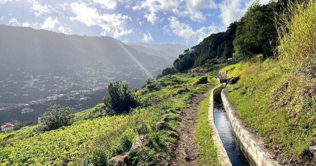
Levada do Risco is my go-to easy hike recommendation in Madeira. It’s located in what I like to think of as the island’s ‘inner belly’, an area with steep green valleys, laurel forest and levadas threading quietly through the slopes.
The out-and-back trail is mostly flat and well-shaded, following the levada through the Laurissilva Forest – at one spot, it rushes downhill in a blur of white – before reaching the Risco waterfall. It’s popular because it’s straightforward and family-friendly, and also because it shares the levada with the popular 25 Fontes trail.
If you’ve got a bit more energy, combining PR6 and PR6.1 makes the hike feel more worthwhile — just expect crowds from mid-morning.
How to get there:
- Park at the PR6/6.1 parking area (arrive early in peak season).
- Take a PR6 hiking transfer.
2. Vereda dos Balcões (PR11)
Best for: Short, easy and flat walk; mountain and forest views
- Distance: 3.1 km
- Elevation gain: 152 m
- Time estimate: 1 – 1.5 hours
- Trail type: Out-and-back
- Booking required? Yes
- View route map on AllTrails

Vereda dos Balcões (PR11) is a low-effort, high-reward walk near Ribeiro Frio. The wide, gentle path follows Levada da Serra do Faial through the forest to a miradouro facing a wall of large, green peaks.
Despite being one of the easiest PR trails to do, it doesn’t feel crowded because the path is so wide and even. On clear days, you can see deep into the central mountains; even on a rainy day, the views I had were beautiful. The viewpoint can be windy once you emerge from the forest, so bring a warm layer.
How to get there:
- Park in Ribeiro Frio (near John’s Poncha).
- SIGA buses 56, 103 or 138 stop in Ribeiro Frio (check timetables in advance).
3. Bica de Cana
Best for: A short hike with epic views; mountain landscapes.
- Distance: 4 km
- Elevation gain: 235 metres
- Time estimate: 1.5 – 2 hours
- Trail type: Circular (option for out-and-back)
- Booking required? Yes
- View route map on AllTrails


Bica de Cana is a short, scenic circuit overlooking the valley of São Vicente. It’s an easy-going route with little elevation gain and incredible views despite how little effort is required.
The trail drops through forest before joining a levada and eventually emerging onto a rocky path where waterfalls spill overhead (expect to get wet). I recommend starting the hike clockwise because after the waterfalls, the path is often overgrown. I simply doubled back instead of completing the full loop.
How to get there:
- Park beside the trailhead or next to Bica de Cana campsite.
4. Caminho das Voltas to Curral das Freiras (Nun’s Valley)
Best for: Completely downhill hike; mountain views; accessible by bus
- Distance: 1.5 – 2 hours
- Elevation gain: 50 m
- Time estimate: 1.5 – 2 hours
- Trail type: Point-to-point
- Booking required? No
- View route map on AllTrails (end the hike in Curral Das Freiras)


Caminho das Voltas – or as I call it, ‘the Nun’s Valley zig-zag’ – was the first hike I ever completed in Madeira, and as well as having incredible mountain views, it’s completely accessible by bus from Funchal.
The walk starts at the Eira do Serrado viewpoint above Curral das Freiras (Nun’s Valley), right in the centre of the island. Once you leave the hotel and miradouro (don’t miss the views at the coffee shop!), you’ll follow a wide path downhill to the village.
The descent is hard on the knees, and there’s limited shade, but the good news is that you don’t need to hike back up because you can simply catch the same bus back to Funchal from the village.
How to get there:
- Drive to Eira do Serrado or take bus no.81 (marked b or e) from Funchal.
- Return by bus from Curral das Freiras.
5. Levada das Rabaças
Best for: Low effort; mountain views
- Distance: 6km
- Elevation gain: 294 m
- Time estimate: 2 – 2.5 hours
- Trail type: Out-and-back
- Booking required? No
- View route map on AllTrails


Levada das Rabaças is one of those easy trails most first-time visitors overlook. Starting at the PR17 trailhead, it follows a quiet levada through a green valley with steep peaks.
The path is mostly on dirt, with minimal incline and no steep drop-offs. It’s noticeably quieter than many of the island’s better-known levada walks, making it a good choice if you’re looking for somewhere peaceful and low-effort. It’s simple, scenic and easy to follow, with lots of lovely plants and flowers along the route.
Read my full guide to the Levada das Rabaças hike.
How to get there:
- Park below Snack Bar Restaurante Boca Da Encumeada (toilets available if you buy something).
6. Levada dos Maroços
Best for: Seeing rural Madeira; easy, flat hike
- Distance: 6.5 km
- Elevation gain: 363 m
- Time estimate: 2.5 – 3 hours
- Trail type: Out-and-back
- Booking required? No
- View route map on AllTrails
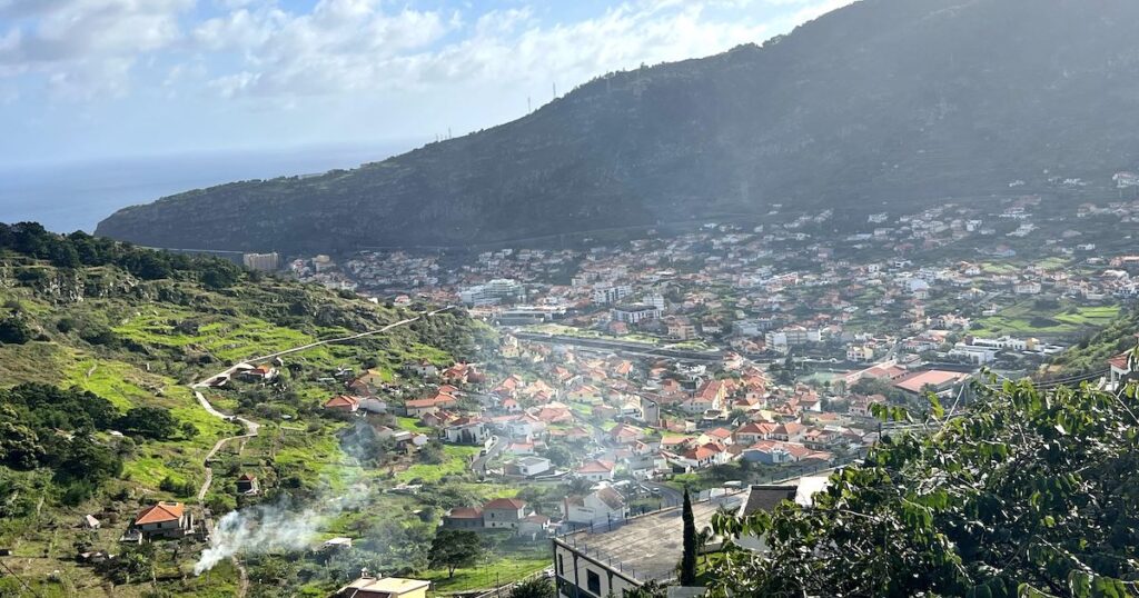
Levada dos Maroços is one of my go-to easy hikes on the east coast, above Machico. It traces the levada above the city and into rural villages, passing small houses and lush green valleys.
The great thing about Levada dos Maroços is that you can hike as far as you want; my usual route takes around 2.5 hours, but you can walk all the way to the village of Maroços and back if you like.
The terrain is mostly flat, a little narrow in some places, but it’s good for trail running or mountain biking as long as it’s not too muddy (after rain). It’s not a crowded trail, either; just watch for mountain bikers.
Read my full guide to hiking Levada dos Maroços.
How to get there:
- Park along the road before the tunnel from Machico to Caniçal (limited roadside space).
Best Moderate Hikes in Madeira
Now for the best walks in Madeira for those who don’t want to go too crazy, but also fancy working up a decent sweat.
These trails are ideal for hikers who walk regularly for 1-3 hours back home, or people of a good fitness level who want to get a good feel for the hiking trails in Madeira.
Compared to the previous trails, they’re either longer and/or harder, with a more challenging elevation gain (typically 400+ metres). They may also feature elements such as steep drop-offs alongside the path, requiring good balance and coordination.
1. Vereda da Ponta de São Lourenço (PR8)
Best for: Iconic hike on a dusty peninsula; completely different scenery.
- Distance: 10.5 km
- Elevation gain: 510 m
- Time estimate: 3.5 – 4 hours
- Trail type: Out-and-back
- Booking required? Yes
- View route map on AllTrails

Vereda da Ponta de São Lourenço is one of the most iconic hikes in Madeira. The scenery at this coastal path feels distinctly different, with dusty orange rock, sparse vegetation and views over the ocean. The trail is well-maintained and easy to follow, but it’s also windy and there’s very little shade.
It’s also one of the busiest hikes in Madeira. I was lucky enough to do it for sunrise – before the days of hike bookings – but nowadays, my best advice is to do as early a slot as possible. If you want a quieter coastal hike, Vereda do Larano is my favourite alternative.
How to get there:
- Take SAM bus no. 113 to the trailhead.
- Park at one of the car parks near the trailhead (some are closer than others).
- Or use a PR8 hiking transfer.
2. Levada do Moinho and Levada Nova (PR7 and 7.1)
Best for: Valley views; levada and waterfalls
- Distance: 9.3 km
- Elevation gain: 573 m
- Time estimate: 3.5 – 4 hours
- Trail type: Circular
- Booking required? Yes
- View route map on AllTrails


This is one of my favourite levada walks. Located near Ponta do Sol, it’s oh-so scenic, varied and genuinely memorable.
You begin on Levada do Moinho, where there are views down a green valley, then enter the forest before re-emerging (up some stairs) on Levada Nova. On the higher levada, the path goes underneath a rock canopy with waterfalls spilling overhead.
The main thing to note is that the Levada Nova section becomes narrow and very exposed, with a steep drop down on one side. With wind added, it’s a hike where you want to move carefully and confidently. I did this hike with two older family members, who chose to do Levada do Moinho out-and-back as a safer, gentler alternative.
How to get there:
- Park near the trailhead (limited spaces; street parking within 10-15 minutes’ walk).
- Or take a PR7 hiking transfer.
3. Levada das 25 Fontes (PR6)
Best for: An moderate hike with waterfalls and valley views
- Distance: 7.6 km
- Elevation gain: 465 m
- Time estimate: 3 – 3.5 hours
- Trail type: Out-and-back
- Booking required? Yes
- View route map on AllTrails

Levada das 25 Fontes is a classic Madeira hike in the Rabaçal Valley. It’s popular for a reason: it begins in a green valley before entering a pretty, shaded Laurissilva forest, before reaching a rocky ‘waterfall’ with dozens of small streams trickling into a deep plunge pool.
It’s a step up from the Risco waterfall walk in distance and elevation, but still, I see plenty of families and beginner hikers doing it with no trouble. Crowds are the biggest downside of this hike; every time I’ve been, the waterfall area is packed, and narrow sections can feel like a queue.
How to get there:
- Park at the PR6/6.1 parking area (arrive early).
- Or take a PR6 hiking transfer.
4. Vereda do Larano and Boca do Risco
Best for: Coastal hike; less-busy alternative; epic views.
- Distance: 9.8 km
- Elevation gain: 953 m
- Time estimate: 4 – 5 hours
- Trail type: Out-and-back
- Booking required? No
- View route map on AllTrails

Vereda do Larano is hands down one of the best walks in Madeira, and it’s still very much underrated. The path hugs the cliffs above the east coast, with views over Eagle Rock in Porta do Cruz and the distant São Lourenço.
You can keep it moderate by doing an out-and-back route along Larano and turning around whenever you feel like it. The complete route with Boca do Risco makes it more challenging, especially thanks to the gruelling uphill section into the forest near the beginning.
Either way, this is one of the best alternatives to São Lourenço if you dislike crowds – I love it so much that I’ve done it three times, in rain or shine.
How to get there:
- Park just after the old cable car station (don’t go any further – turning around is painful).
- Or join this hiking trip with a local (on Tuesdays only).
5. Pico do Facho (Machico)
Best for: Small mountain hike; ocean views
- Distance: 3.2 km
- Elevation gain: 362 m
- Time estimate: 2 – 2.5 hours
- Trail type: Out-and-back
- Booking required? No
- View route map on AllTrails

Pico do Facho is a fantastic small mountain hike and, in my opinion, one of the best walks in Madeira if you want to summit a mountain without working incredibly hard. It’s located in Machico, on the east coast, and has views both over the bay, distant peaks (on clear days) and São Lourenço.
The out-and-back route is short and scenic, up a mix of a levada path, dirt track and steel staircases. Better yet, it starts and ends near the sandy beach. I’ve done the route up and down Pico do Facho 5+ times during my time living in Machico, and I love extending the route to Ribeira de Natal Beach in Caniçal.
Read my full guide to hiking Pico do Facho.
How to get there:
- Take SIGA bus no. 113 from Funchal.
- Park next to the trailhead (limited spaces) or at Machico Beach.
6. Levada dos Tornos
Best for: Accessible by bus from Funchal; city views and Monte visit
- Distance: 6.7 km
- Elevation gain: 327 m
- Time estimate: 2.5 – 3 hours
- Trail type: Point-to-point
- Booking required? No
- View route map on AllTrails

I simply couldn’t do a Madeira hiking guide without mentioning Levada dos Tornos. Not only is this hike accessible by bus from Funchal, but it’s also uncrowded and full of city and valley views.
I like to begin this levada hike at Jasmin Tea House (accessible by bus or Bolt from Funchal) and end it at Monte Palace, before taking the cable car or bus down to the city.
It’s a great half-day hike if you want something scenic without a big commitment. Just expect to encounter some mud after rain.
How to get there:
- Take bus no. 47 from Funchal to Jasmin Tea House.
7. Eagle Rock (Penha de Águia)
Best for: Small mountain hike; coastal and countryside views
- Distance: 3.5 km
- Elevation gain: 435 m
- Time estimate: 2 – 2.5 hours
- Trail type: Out-and-back (option for circular)
- Booking required? No
- View route map on AllTrails

I will always have a soft spot for the Penha de Águia (Eagle Rock) hike in Porto da Cruz. It may not be the biggest of mountain hikes in Madeira, but it makes you work.
The path starts out very steep (on a combination of dirt and rocks – not recommended after heavy rain) before reaching two very beautiful viewpoints over the town, ocean and back valleys.
Most hikers take the same way back down (quick, but hard on the knees). I also tried the longer circular route via Ribeira do Faial for a bigger challenge – the loop is prettier, but the direct out-and-back route is still breathtaking on its own.
How to get there:
- Hike from snack bar Adega da Cruz (limited roadside parking).
8. Levada da Rocha Vermelha and 25 Fontes (PR6 and PR28)
Best for: Less-busy alternative to 25 Fontes; two waterfalls in one
- Distance: 10.8 km
- Elevation gain: 604 m
- Time estimate: 4 – 4.5 hours
- Trail type: Circular
- Booking required? Yes
- View route map on AllTrails

I love the Rabaçal Valley, but I don’t love crowded trails. Rocha Vermelha is the solution, a lesser-known alternative to 25 Fontes and the Risco Waterfall. This hike begins with 25 Fontes (the option’s there to skip it entirely) before it doubles back and moves onto the uncrowded Levada da Rocha Vermelha.
The standout is the waterfall on Rocha Vermelha. On my visit, we had it completely to ourselves and ended up swimming. Expect tunnels later along the levada (bring a torch), wet areas near the waterfalls and sun exposure out of the forest.
How to get there:
- Park in the small car park near Túnel do Cavalo (spaces are limited).
9. Levada do Castelejo
Best for: Uncrowded levada hike; mountain and countryside views
- Distance: 10.8 km
- Elevation gain: 392 m
- Time estimate: 3.5 – 4 hours
- Trail type: Out-and-back
- Booking required? No
- View route map on AllTrails


My rendition of Levada do Castelejo is a quiet, make-your-own-distance walk above Porto da Cruz. It’s ideal if you want a scenic hike without too much incline. The levada walk passes rural houses and small forest sections, with regular views of Eagle Rock and the ocean.
I’ve done the hike from both ends. Starting near Bar Hercules is a little bit easier parking-wise, but the opposite side gives you better views of Eagle Rock early on and it means you can stop at Bar Hercules mid-hike for a coffee.
In all, this is a relaxed, uncrowded route that feels local (with honesty stalls selling fruit and veg along the route) that I didn’t hesitate to take my parents on.
Read my full guide to the Levada do Castelejo hike.
How to get there:
- Park near the football pitch, or on Caminho da Referta if hiking from Bar Hercules.
10. Caminho Real to the São Cristóvão Viewpoint
Best for: Coastal views; less-busy hike
- Distance: 4.3 km
- Elevation gain: 298 m
- Time estimate: 1.5 – 2 hours
- Trail type: Out-and-back
- Booking required? No
- View route map on AllTrails


I like the Caminho Real to the São Cristóvão Viewpoint because you get great coastal views without a huge climb. The trail is famous for its ‘zig-zag’ from the clifftop down to Bar São Cristóvão, which looks up at the path and the large, green peak behind it.
It’s a moderate challenge on the way back up, especially if you’ve helped yourself to a pastel de nata in the snack bar. Note that the path has a big drop down to the ocean; there are railings in place and viewpoints throughout.
There are also some loose rocks on the path, from the cliff. If you’re driving, the nearby Cabo Aéreo Café Restaurant is a great post-hike stop.
How to get there:
- Park in Arco de Sao Jorge; the trail begins near O Arco restaurant.
11. Levada do Caniçal
Best for: Views of the east coast; lesser-known hike
- Distance: 8.3 km
- Elevation gain: 426 m
- Time estimate: 3 – 3.5 hours
- Trail type: Out-and-back
- Booking required? No
- View route map on AllTrails


Levada do Caniçal isn’t one of the best hikes in Madeira if you’re looking for dramatic views, but it’s uncrowded and peaceful. You get views of Ponta de São Lourenço and the fishing village below. It’s also easy to reach from Machico and other locations on the east coast.
The path can be narrow in places, and there are a few drop-offs (with makeshift railings) along the route. You can easily combine this hike with a trip to the sandy beach in Machico.
How to get there:
- Park on the small road next to the trailhead (space is limited).
12. Levada dos Tornos From Lombo do Urzal (Boaventura)
Best for: Quiet hike on the north coast; forest setting
- Distance: 5 km
- Elevation gain: 345 m
- Time estimate: 2 – 3 hours
- Trail type: Out-and-back
- Booking required? No
- View route map on AllTrails


I’ve already covered a section of Levada dos Tornos from Funchal. However, this lengthy levada reaches all the way to the north, and this side is way less busy.
The village where the hike begins, Lombo do Urzal, is tiny and steep, with very few houses. The hike, too, is quieter – leafy, mostly in shade through the forest, before it emerges into a green valley with big mountains looming overhead.
We didn’t see another hiker the whole time, which is truly rare in Madeira. It’s not my top recommendation for first-timers hiking in Madeira (it’s less “wow” and more peaceful). However, if you’re staying on the north coast near Boaventura, it’s a decent option.
How to get there:
- Park in the village near Levada dos Tornos (note the roads get steep)
Best Challenging Hikes in Madeira
For my third and final section, I’m going to share the best hikes in Madeira for seasoned hikers and anyone who wants a bigger challenge.
These routes pack in longer distances, extra elevation gain and/or conditions that’ll require experience (scrambling, for example). For these hikes, you’ll need plenty of hiking experience, a good forecast and a great level of fitness.
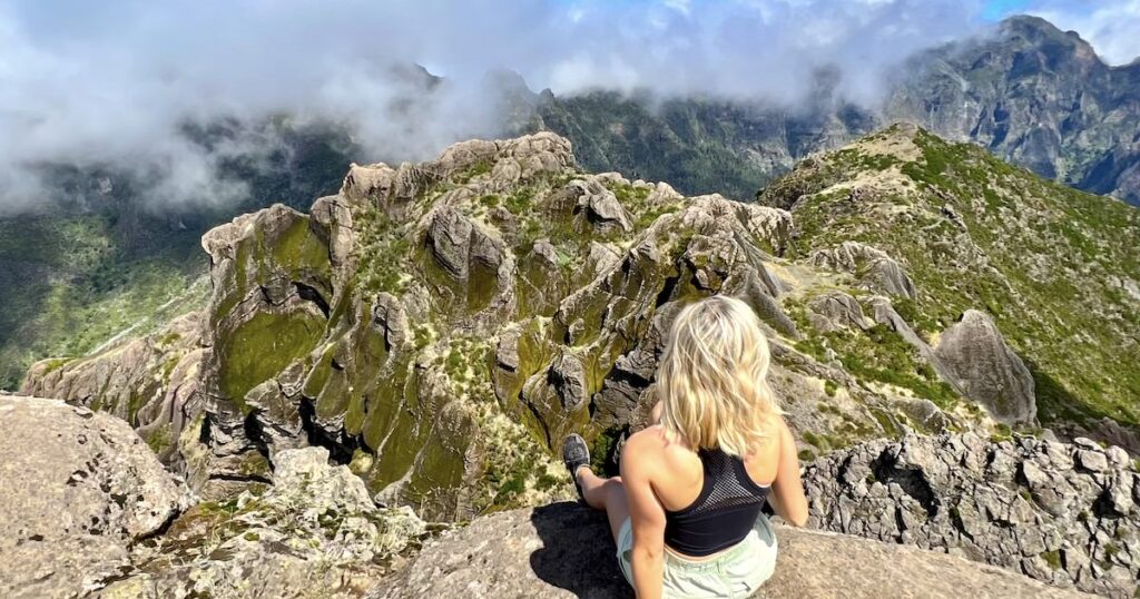
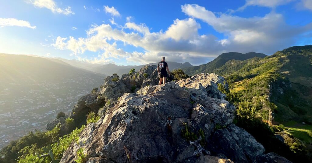
1. Pico do Arieiro to Pico Ruivo (PR1)
Best for: Confident hikers; iconic ridge trail in the mountains
- Distance: 8.7 km
- Elevation gain: 955 m
- Time estimate: 4.5 – 5 hours
- Trail type: Point-to-point
- Booking required? Yes
- View route map on AllTrails

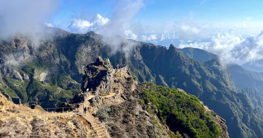
Pico do Arieiro to Pico Ruivo (PR1), also known as ‘Pico to Pico’, is what most people consider to be the best hiking trail in Madeira. Honestly, it’s worthy of the title.
The dramatic trail begins at Pico do Arieiro (1,818 metres) and ends at Pico Ruivo (1,862 metres), the highest mountain in Madeira. On the way, it passes through tunnels, staircases and those famous views of chiselled, green mountains and razor-sharp peaks.
It’s not for the faint of heart. Closures are common due to rockfall and weather, and when the route is open, it attracts crowds all day long. There are narrow sections with steep drops on either side, which can feel intense if you’re not used to heights.
Plus, it’s a lot of work: the point-to-point route ending at Achada do Teixeira (the pick-up point for cars) has 955 metres of elevation gain. Still, it’s absolutely worth it if you’re fit, confident on exposed paths and go in with realistic expectations.
How to get there:
- Use a PR1 hiking transfer (recommended).
- Or if you’re very fit, try it out-and-back (high difficulty).
2. Pico Grande
Best for: A less-crowded alternative to PR1; epic views and scrambling
- Distance: 9.7 km
- Elevation gain: 841 m
- Time estimate: 3.5 – 5 hours
- Trail type: Out-and-back
- Booking required? Yes (via PR12)
- View route map on AllTrails
Pico Grande is one of my favourite “serious” mountain hikes in Madeira. It’s far quieter than PR1, but the views are just as spectacular near the top. I’ve hiked to the summit using two different routes, but my recommendation is the path via the Caminho Real da Encumeada (PR12), which is easily accessible from Funchal by car.
It’s a wide, well-kept path most of the way, but it gets narrower and scarier towards the end – with some exposed areas, plus a short but intimidating scramble to the summit.
It’s okay to stop short if you don’t feel comfortable with that final section, but the best views are at the very top. Crowd levels are light on the trail, which makes it feel all the more spectacular.
How to get there:
- Park at the Boca da Corrida viewpoint; spaces are limited.
3. O Caminho do Pináculo e Folhadal (PR17)
Best for: Varied hike with waterfalls and mountain views; challenging
- Distance: 15+ km
- Elevation gain: 1,200 m
- Time estimate: 6 – 9 hours
- Trail type: Point-to-point (option for circular)
- Booking required? Yes
- View route map on AllTrails


The PR17 is one of the best hiking trails in Madeira if you’re up for the challenge. It’s one of the most varied too, with multiple waterfalls, tunnels and forest. The last stretch below Bica de Cana is especially pretty, with waterfalls falling on the path and views of the mountains.
It’s traditionally a point-to-point hike, which is awkward with one car. When I did it, we parked at Encumeada, completed the trail, and then walked back to the car along the old road (ER105) – you need to watch out for loose rock and cliffside conditions on this road.
The official trail is well-maintained but slippery around the waterfalls, and it’s a big day out even for experienced hikers.
How to get there:
- Park below Snack Bar Restaurante Boca Da Encumeada.
- For the reverse direction, park at the PR17 endpoint.
4. Levada do Paul
Best for: Sunny trail with big open views; a challenge
- Distance: 17.7 km
- Elevation gain: 639 m
- Time estimate: 5.5 – 6 hours
- Trail type: Out-and-back
- Booking required? No
- View route map on AllTrails


Levada do Paul is a long, scenic out-and-back hike suspended above a green valley, with Bica de Cana as the halfway point.
Windmills are dotted over the surrounding ridges, and in the distance, you can see all the way down to the ocean on clear days. It’s stunning but it’s also one of those hikes where exposure is a real concern, because sections of the levada run alongside steep drops.
When I attempted this route, the levada was flooded and we didn’t make it to Bica de Cana, so we turned back after the main waterfalls. Honestly, it’s a good reminder of how quickly the conditions can change on Madeira’s levadas, especially after heavy rain. Also note that most of the trail is exposed to the sun and wind, so sun cream and longsleeves will be helpful.
How to get there:
- Park alongside the road near the chapel.
Levada Walks vs Mountain Hikes
One of the best parts about hiking in Madeira is the variety. Trails typically fall under two categories: levada walks and mountain hikes.
What Are Levadas?
Levadas are irrigation channels that move water throughout Madeira, from the mountains and wet north coast to the drier south. Narrow paths, traditionally used for maintenance, run alongside them. Nowadays, many of these are official hiking trails.
Because of the nature of the irrigation channels, they are:
- Usually relatively flat and steady
- Often sheltered (through forest)
- Longer in distance but less steep
- Home to features like tunnels, waterfalls and lush vegetation
Mountain hikes

Mountain hikes, on the other hand, tend to have more elevation gain and often cooler temperatures. These trails may have steep drop-offs, small scrambles or stairs.
They can be more physically demanding or require good balance, but they have the cloudy mountain views that Madeira is known for.
They often include:
- Steep stairs or slopes
- More elevation gain in a short distance
- Exposed ridges and drop-offs
- Windier, colder conditions
| Levada Walks | Mountain Hikes |
|---|---|
| ✓ Usually incline is more gradual | ✓ Dramatic scenery |
| ✓ Often shaded | ✓ Feels adventurous and challenging |
| ✓ Good for steady half-day hikes | ✓ Offers more variety |
| ✘ They can be narrow | ✘ Steep climbs and extra incline |
| ✘ Prone to flooding | ✘ More weather-dependent |
| ✘ Less variety | ✘ May have steep drop-offs |
Best Hikes in Madeira Without A Car
You don’t need a car to go hiking in Madeira, but you do need to plan carefully and consider that you won’t be able to reach each and every trail on the island.
Some hikes are accessible by bus (e.g. the Nun’s Valley zig-zag and Levada dos Tornos to Monte) and hiking transfers are available for popular point-to-point trails like PR1 and PR8.
Rather than share everything here, I’ve written a detailed breakdown on transport options and trail options in my complete guide to hiking in Madeira without a car.
Practical Tips for Hiking in Madeira
I want to end this hiking guide with a few final things I’ve learned from six months of hiking on the island:
1. The Weather Changes Fast
Madeira has many microclimates. Even if it’s bright and sunny on the coast, it can be windy and rainy in the mountains; in Madeira, there’s the saying, “Madeira is wearing its hat”. The conditions can change quickly at altitude, and it also gets noticeably colder the higher you climb.
Always:
- Check the island webcams for conditions in the mountains, not just Funchal.
- Bring layers and waterproof gear on every hike, especially if it’s in the mountains.
- Be prepared to turn back if the visibility drops suddenly on the trail.
2. Tunnels Are Everywhere
I’ve lost count of the number of tunnels I’ve hiked through. They’re common on levada walks. For the short tunnels, you can get through without using a torch, but for the longer tunnels, you’ll need one. A headtorch is ideal, or at the very least, you can use a phone with a strong torch.
3. Your Gear Matters
In Madeira, I always hike in Goretex (waterproof) trail runners or hiking boots with a good grip, sweat-wicking layers and a comfortable bag with essentials such as first-aid, a waterproof rain jacket and 2 -3 litres of water per person.
I also download an offline map of the trail on my phone because reception isn’t always guaranteed in the mountains and remote areas.
I hope you found my guide to the best hikes in Madeira helpful! I’d love to hear your experience and favourite hikes in the comments.


